Mt. Guiting-guiting is lying in the island of Sibuyan in the Province of Romblon. This mountain serves as the divider of the three municipalities of Magdiwang, San Fernando and Cajidiocan. G2 (another name given) got the most difficult and challenging mountain in the Philippines together with Mt. Halcon in Mindoro and Mt. Mantalingajan in Palawan, well, these 3 mountains are all lying in Southern Tagalog Region.

The so called "Knife Edge" of G2 added an amazing experience to all mountaineers. Look at the photo above. It is truly gorgeous in the photo right? But in reality you'll get a ghost bumps if you are in front of it. It seems that you're in the world of Lord of the Ring because of the rocks in different forms. Next will be the famous "Kiss the Wall" which I am afraid of. I read a lot of articles about this part, and I felt 50-50 in crossing it, but as you continue reading, you'll find how I survived the "Reverse-Traverse."
Day 1 at Brgy. Tampayan, Magdiwang, Romblon. We started early in the morning at around 0600 hrs. We walked for about a kilometer distance and crossed three rivers just to reach the DENR Office for a short meeting with the PASU. It was just a briefing about the DO's and DONT's while on the trail of the mountain. The whole briefing lasted for less than 30 minutes, but we stayed at DENR for more than an hour because Frank (our new found friend from Switzerland) was the first one who was with PASU for the briefing, together with his own guide. We signed a form and paid 300 pesos for the registration.

When we're done, we started ascending. The trail we're talking about is going to Camp 1. For me, the trail in this part was simple and with similarities to the other mountains of Southern Luzon. The same thing, almost 75 percent were covered with trees that gave shade to us. I noticed that the trees and other plants were still untouched and still virgin in this area. My first photo taken in camp 1 was at around 0914 hrs. Then we took an hour break in this camp. We rested and took our early lunch break. Camp 1 is just a small area, uneven ground and can accommodate only 3 tadpole tents. We left this camp with smile and refreshed.
The next part was the trail that connects Camp 1 to Camp 2. It was a steeper trail compared to the first one. The ambiance is colder because the elevation became higher. The trail is still covered with trees and plants. My first photo taken at Camp 2 was at around 1148 hrs. Camp 2 is wider and can accommodate five tadpole tents. We rested here for 30 minutes then proceeded.
The next part is the trail that connects Camp 2 to Camp 3. This part wasn't that hard, but the dried woods and shrubs that created the trail like an obstacle course, wherein you need to bend you body to be able to reach the next camp. I just want to give a special thanks to Jae for his last piece of SkyFlakes biscuit that served as our magic beans (if you're watching Dragon Ballz.) Drew and Jeff were more than 30 minutes far from us, so when we reached the Camp 3, we took a short nap while Sir Richard went to Bulod's Spring and fetched water. When the two arrived, we took break then proceeded to Bulod's Spring.


05:58PM, I and Drew reached the Mayo's Peak. The pain was easily removed after seeing all those gorgeous richness that the province can be proud of. The cold wind easily blew the sweat on our faces and our wet shirts were embraced by the darkness. We just left our loads at the campsite then we went to view deck trying to take few more shots of the "Knife Edge" while the sun was saying BYE BYE to us on our first day!
When we're fine with our photos, we went back to the campsite and pitched our tents on the area that has a soft soil because the ground was still wet that time. We prepared our dinner after that, our cook that night was Sir Jef, Drew as the stove operator, Jae as the veggies chopper and I was like the porcelain displayed inside the cabinet in the kitchen while they were so busy, hahaha. Pork Sinigang, plain rice were just part of our dinner. The food that we ate were so great and stunningly done by our chef. Thanks Jef! And we slept happily ever after.

Introducing my trail buddy, Jae from Cavite. Since we woke up early and the rest were still sleeping, we went back to view deck to witness the sunrise. I felt the same thing this time; afraid and still amused with the gorgeous formation of the mountain. We stayed there for just few minutes then went back to the camp site for breakfast preparation. Of course, Chef Jeff is the still in charge of our food.
At around 8AM we left Mayo's Peak and started crossing the "Knife Edge." At first, my knees were both shaking while stepping on the boulders of the trail. But, as the time goes by, I was able to get the right rhythm on each boulders. "Knife Edge" already got the 9/9 rating in terms of difficulty, so it wasn't a simple trek. Check the photos below and imagine how we survived the first part of the 2nd Day.


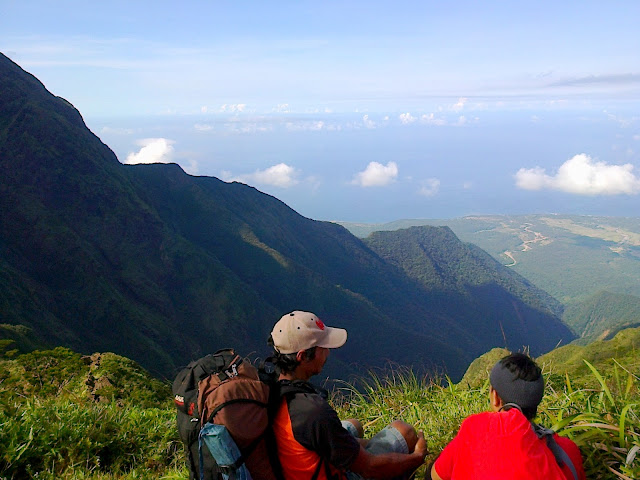
At around 8AM we left Mayo's Peak and started crossing the "Knife Edge." At first, my knees were both shaking while stepping on the boulders of the trail. But, as the time goes by, I was able to get the right rhythm on each boulders. "Knife Edge" already got the 9/9 rating in terms of difficulty, so it wasn't a simple trek. Check the photos below and imagine how we survived the first part of the 2nd Day.


Sir Richard and Jae are those in the picture above. They were talking about the next challenge that we'll be encountering for this day. Knife Edge was really challenging because of its sharp boulders on the narrow trail. The butterflies were flying and doing the hop on, hop off on every flowers along the side. The colorful ornamental and some pitcher plants can also be found in this part. I've got a lot photos showing how gorgeous the G2 formation is.
 That's Sir Richard and Jae, while counting the boulders that we might hop on and off. I forgot if where's the location of this photo, but I think it's just few steps before "Kiss the Wall" which is in the photo below. Look at those rocks, the cracks can invade your fear if you're not into rock climbing /scrambling. Security was very important here, because every steps need to be a hundred percent secured. Your grip must be exerted well, but the green color from the plants added a great complimentary color to the rocks.
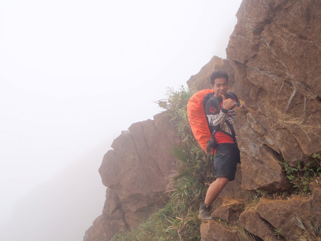


That's Drew enjoying the well known part of G2 - "Kiss the Wall." You must have a clean heart and have the positive outlook in life while crossing this, hahaha. After I uploaded this photo in facebook, a lot of my friends asked me if how's the Kiss the Wall, I just simply replied: It was a great experience crossing that huge stone while your face was almost touching the wall and that's why it called Kiss the Wall, very self explanatory. Another thing that I can't forget was the Coca-cola that our guide brought. We didn't expect that he'll bring a 2L soda for us. Then, he challenged us that if who'll be the first one to reach the summit, then he'll be the first one to take few gulps from his soda. TOTALLY REMARKABLE! After "Kiss the Wall" was another rock climbing part going to the Peak of Deception or can be considered as the Peak of Decision. Here, you need to decide if you'll proceed or not. [The Peak of Deception is just 30-45 minutes from the summit itself, so by 02:40PM we reached the summit. As what I've mentioned above, we had a soda party there, thanks to our guide.] If you're done deciding, here comes "Hillary Pass" the 90 degrees assault going to the summit. It is said to be impassable during rainy season, but according to Sir Richard, mostly the foreigners love G2 every rainy days, while the Filipinos are sunny days - maybe they have a lot gears. It was a 3-meter high rock climbing without using ropes (although I have one) and at your back is a cliff that measures more than a thousand meters above sea level.


The photo above was taken few minutes after stepping on the summit. As you can notice, we didn't have a greeting clearing that time. Since G2 was kind to us, it gave us less than five minutes of great view in 360 degrees of the mountain, then went back to foggy ambiance. We were able to see the gorgeous contour, the horizon and the sea surrounding Sibuyan Island. The summit is not suitable for camping because of the strong wind and the small area. If I am not mistaken, DENR mentioned that the camp site located few meters from the summit is ONLY FOR E-CAMP purposes.
We cooked our dinner on the summit while we're waiting for the clearing; since we'll be leaving the summit passed 03:00PM, we expected to reach San Fernando's Camp 3 (the camp site) at around 08:00PM. So at least no need for us to cook in the darkness.


We cooked our dinner on the summit while we're waiting for the clearing; since we'll be leaving the summit passed 03:00PM, we expected to reach San Fernando's Camp 3 (the camp site) at around 08:00PM. So at least no need for us to cook in the darkness.

Next part was "Walk of Fame" which is the easiest part of G2. We were like walking in the part with bermuda grass on the ground. Here, you still can see what will be the next part and the challenges that the trail might bring for us.

If you can see the hill-like part of G2 in the picture above (hill on the left), it's the Peak of Deception then the summit (on the right.) As what you can see on the picture, G2 is composed of huge rocks covered with green grass. Ascending to summit was easier than descending it.

The picture above was near the Crash Site. According to our guide, there was a plane crash happened in 1995. When the plane was considered missing, they thought that it crashed somewhere in Mt. Halcon in Mindoro. But, during the trail exploration, the residents noticed the plane. When the residents went to the exact area to check what happened, they saw skeletons in the crashed site and another skeleton found embracing on the trunk of a tree nearby. So that means, the person was still alive after the plane crashed? Then maybe because of physical damage, hungry and other instances, he/she died. I don't like to put comments about this story, let the investigators do their job. Anyways, the photo above shows a part of the plane.
 |
| The Sun set in Sibuyan Sea |

We finally reached Camp 3 at around 08:00PM. Our shirts and pants were all wet after reaching the camp site. We rested for 30 minutes before we pitched our tents and then took our dinner. (Please refer to the picture above) The blue tent on top belongs to our guide, brownish green in the middle was occupied by Jae and myself then Jeff and Drew occupied the royal blue. We experienced lightning and thunder that night, but there's no rain. We encountered water shortage, so we badly needed a water source. The water source few meters from camp 3 was empty, so we didn't have a choice but to divide our water to 400ML each.
We woke up early in the morning and prepared ourselves for another challenge. We took a breakfast then packed rice and adobo as our trail food. Sir Richard, Jae and I decided to leave the camp site first, then Jeff and Drew will follow us. Because our water was short, we'll be going to descend as faster as we can up to the river (the only water source which is 4hrs away) then, Sir Richard and Jae will get water then go back again for the remaining two.
We were all in a hurry this time, so from Camp 3 to Camp 2 we got it within 45 minutes instead of one hour. The trail here was simple but still needing your focus because on the side was a cliff. There were up and downhill in this part. Our trail water here was only 300ML for us, because we already consumed the other half during our breakfast (not including Sir Richard)
The sun begun to shine when we're taking the trail from Camp 2 to Camp 1. This part was longer, so we made it for 1 hour and 45 minutes. This was the most difficult part of our traverse, because the trail has a 90 degrees uphill and downhill part. The rocks were still part of the trail, so we were just holding on the plant's branches just to get the proper balance. Plus, given the fact that we were all dehydrated and our knees were shaking. Our inspiration that time was the clean cold water that the river has. If you're familiar with James Franco's movie 127-Hours, when he was already dehydrated, that's almost our scenario. But the water in the Pitcher Plants were a huge help in surviving our thirst.
 We already forgot that we were aiming for faster pace because we were focusing on getting the water inside the pitcher plant. We didn't care if there were ants, flies and kiti-kiti (larva of the mosquitoes) in the water, as long as it can prevent dehydration. I think those insects will be digested by the acids in my intestines, so no worries about it. But, another thing I've knew, each of the pitcher plant has different taste, depending on its type. There were water that tasted normal, sour, bitter and sweet, I think that depends on the organisms inside the plant. hahaha.
Although our knees were shaking, we still did our best to finish the trail of Camp 1 to the river. Since we already emptied our 300ML water, Sir Richard gave his 50ML water, remaining in his 2L bottle. We rested again for 15 minutes before leaving the site. We trekked this part for 1.5 hrs. Afar from us, we've heard the sound of the chainsaw, indication that there were people nearby that we could ask for a water. We shouted loudly, but no response from them. We also noticed a smoke nearby, seemed to be a bee catcher, but we still got nothing, so, we had no choice but to proceed. Since, the trail wasn't that complicated, Sir Richard decided to make his pace faster, then he'll get water in the river, then he'll be back for us with water.
Our inspiration that time was still the same thing - the river. We still made our best just to overcome our fear which is dehydration. The pitcher plants were still there and were giving us their unique taste. And as I drink their juices, I felt am gonna puke, so I've stopped it! With Jae, we continued walking when we've saw the certain part of the river, then we've heard sound of a flowing water, so we made our pace faster.
To make our story short, we've reached an open area, with cogon grass on the side of the trail and Sir Richard was running hurriedly, bringing his 2L bottle filled with water. Honestly, I got a teary eyes that time and I will not forget that feeling (combination of happiness and thankfulness that we've survived.) There was an open space with 1 tree planted in the middle and a hut 5 meters away.


We woke up early in the morning and prepared ourselves for another challenge. We took a breakfast then packed rice and adobo as our trail food. Sir Richard, Jae and I decided to leave the camp site first, then Jeff and Drew will follow us. Because our water was short, we'll be going to descend as faster as we can up to the river (the only water source which is 4hrs away) then, Sir Richard and Jae will get water then go back again for the remaining two.
We were all in a hurry this time, so from Camp 3 to Camp 2 we got it within 45 minutes instead of one hour. The trail here was simple but still needing your focus because on the side was a cliff. There were up and downhill in this part. Our trail water here was only 300ML for us, because we already consumed the other half during our breakfast (not including Sir Richard)
The sun begun to shine when we're taking the trail from Camp 2 to Camp 1. This part was longer, so we made it for 1 hour and 45 minutes. This was the most difficult part of our traverse, because the trail has a 90 degrees uphill and downhill part. The rocks were still part of the trail, so we were just holding on the plant's branches just to get the proper balance. Plus, given the fact that we were all dehydrated and our knees were shaking. Our inspiration that time was the clean cold water that the river has. If you're familiar with James Franco's movie 127-Hours, when he was already dehydrated, that's almost our scenario. But the water in the Pitcher Plants were a huge help in surviving our thirst.
Although our knees were shaking, we still did our best to finish the trail of Camp 1 to the river. Since we already emptied our 300ML water, Sir Richard gave his 50ML water, remaining in his 2L bottle. We rested again for 15 minutes before leaving the site. We trekked this part for 1.5 hrs. Afar from us, we've heard the sound of the chainsaw, indication that there were people nearby that we could ask for a water. We shouted loudly, but no response from them. We also noticed a smoke nearby, seemed to be a bee catcher, but we still got nothing, so, we had no choice but to proceed. Since, the trail wasn't that complicated, Sir Richard decided to make his pace faster, then he'll get water in the river, then he'll be back for us with water.
Our inspiration that time was still the same thing - the river. We still made our best just to overcome our fear which is dehydration. The pitcher plants were still there and were giving us their unique taste. And as I drink their juices, I felt am gonna puke, so I've stopped it! With Jae, we continued walking when we've saw the certain part of the river, then we've heard sound of a flowing water, so we made our pace faster.
To make our story short, we've reached an open area, with cogon grass on the side of the trail and Sir Richard was running hurriedly, bringing his 2L bottle filled with water. Honestly, I got a teary eyes that time and I will not forget that feeling (combination of happiness and thankfulness that we've survived.) There was an open space with 1 tree planted in the middle and a hut 5 meters away.

When we've reached the river, we just left our loads on the rock, then dipped our faces into the water for few seconds. Everything was blank that time, nobody was talking and all were busy playing with the water. We were like children that time, we even forgot that we were still wearing our shoes, pants and etc. After swimming, we removed everything we have (excluding our shorts) then lie down on the boulder exposing ourselves to the sun. When we already gained enough energy, we ate our packed lunch. When we're fully recovered, Sir Richard and Jae filled their water bottles then went back to the trail to help Jef and Drew. So I was alone that time and I felt uncomfortable (this is the result of watching Walking Dead)
I slept for few minutes then when I woke up I transferred our loads to the other side of the river, then I hide myself in a boulder. But, after few minutes, I sat on the large boulder, trying to observe the surroundings. Jae and Jeff shouted from afar, so that's the best feeling I ever felt while I was there. Jeff did the same as we did. While we were still waiting for Sir Richard and Drew we cooked everything we have in our backpacks. Of course, Chef Jeff still did his job.
I am wasn't able to get the exact time when Sir Richard and Drew arrived but I think it's within an hour. Sir Richard brought Drew's backpack when they arrived. When Jeff was done cooking, we took our late lunch at around 3PM, rested, then cleaned all the mess in the river. By 4PM, we left the river bringing the memories that G2 gave us.
I slept for few minutes then when I woke up I transferred our loads to the other side of the river, then I hide myself in a boulder. But, after few minutes, I sat on the large boulder, trying to observe the surroundings. Jae and Jeff shouted from afar, so that's the best feeling I ever felt while I was there. Jeff did the same as we did. While we were still waiting for Sir Richard and Drew we cooked everything we have in our backpacks. Of course, Chef Jeff still did his job.
I am wasn't able to get the exact time when Sir Richard and Drew arrived but I think it's within an hour. Sir Richard brought Drew's backpack when they arrived. When Jeff was done cooking, we took our late lunch at around 3PM, rested, then cleaned all the mess in the river. By 4PM, we left the river bringing the memories that G2 gave us.

While on the trail after the river, we witnessed an activity happening in this area. There were a lot of trees being cut, and I don't know if it's legal or not. There was a man who tried to transport uling using his kalesa. I think the sound that we were hearing in Camp 2 was coming from this area. After 1 hour and 30 minutes walk, we finally reached the residents area. We just smiled every time we looked back in Mt. Guiting-guiting (photo above taken at around 5:30PM.)


Here are the cast (from left to right) Jeff - the master chef, Myself - the first lady, Sir Richard - the guide, Jae - the veggies chopper, Sir Remy - head of the guides of San Fernando and Drew - the stove operator
The residents were so kind, they even greeted us on our success that day. They were also smiling on us while doing their household chores. While waiting for our service from Magdiwang, we stayed in the resident's house who sell halo-halo. Then we also had a time to visit Sir Remy's rest house.
When our service arrived, we easily find our position in the tricycle. I was occupying the space at the back of the driver, Sir Richard was in standing mode in front of the trike's sidecar, Jeff was on side of the sidecar (sitting almost on the sidewheel) and Jae and Drew were both inside. Our backpacks were on top load.
We thought we're done with the challenge of G2, but that's not true. The road or maybe that was a highway, sorry I really can't identify, it was already dark. Some part of the roads were uncemented, so it added a challenge to our driver, but he was really good in driving. It seemed that we were like riding a roller coaster. Another thing, the trike's wheel got flat because of the sharp object.
As an end, we reached the Tansionco's residence at around 8PM. Sir Jay Z, Carla and the rest of the Tansionco family were there and already prepared our dinner. THEY WERE REALLY KIND TO US, THANKS TO ALL OF YOU!
The whole Mt. Guiting-guiting journey we had was so UNFORGETTABLE. I will be going to cherish all those memories that we had in this climb. It was my first time meeting all of them, but I felt comfortable being with them. SEE YOU SOON!