Showing posts with label Landmark. Show all posts

Sunday, April 5, 2020

Paoay Sand Dunes

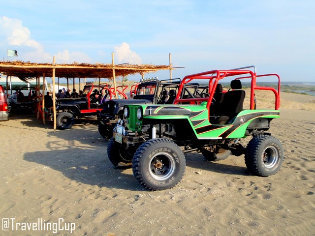
After the century old Paoay Church, it's time for an amazing and extreme adventure in Paoay Sand Dunes. By the way, a friend of mine, who is now working in middle east, I thought, Sand Dunes can only be found in the dessert countries around the world, but it's not!

Here in Ilocos Norte, Philippines, we have the same feature and adventure that the dessert safari have. Also, this place is always part of the Filipino movies, like the dessert scenes. Paoay Sand Dunes has extreme activities like 4 x 4 Ride, sand boarding and All Terrain Vehicle.

The strong wind is the one that creates the dunes and the wavy-like formation on the ground. The grayish sand of Ilocos is really fine and since it's light in weight, the wind can easily carry the sand everywhere. From afar, I saw an oasis (I think) near the shoreline. With trees and small lake (look at the picture above.)

 Paoay Sand Dunes 2020

tourist spots in Ilocos Sur

Paoay Sand Dunes
After the sunny adventure, we got sweat and sticky skin, so time to go back in our van while the rest were still enjoying the wind and the sand. Our foot prints on the sand easily disappeared because the wind moves the grains of the sand fast. After that tiring activities plus our stomach were all starving, we decided to leave the site and proceeded to our next destination which is Vigan City for their Empanada.

Marcos Ancestral House

Since we were all clean and fresh, time to for a heritage site that was used by a powerful family of Ilocos and even the whole Philippines.  We traveled more than two hours from Blue Lagoon going to this must-visit site of the province.  The highway wasn't that crowded because that day was Sunday.


We parked the van just beside the highway near the ancestral house.  Parking space was for free.  After getting off the van, we stretched our muscles and bought cold soda and water.  It was Sunday, so the ancestral was filled with tourists and locals trying to see what's inside the house. 

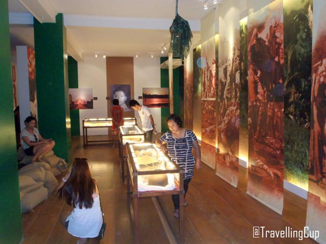
We paid 50 pesos per head and proceeded to the main lobby.  First thing that captured my eyes was: on the right side of the ground floor, the old wooden stair case can be found, covered with red carpet.  On the left side, the presidential table, with three arm chairs.  Then, the management provided mono-block chairs in front of the wide screen showing the history of the late President Ferdinand Marcos.  Then, the whole second floor is divided into different panels, please see the photos below.

Marcos Ancestral House 2020
Malacanang of the North
Marcos Ancestral House
This house served as the office of the late Don Mariano Marcos, the president's father when he was the congressman.  It was also used as an office of Imee Marcos, the president's daughter, when she was the Ilocos Norte Representative.  She even lived in this mansion within her term.  Bongbong Marcos, the presidential son, also moved into this house when he was the governor of Ilocos.


Marcos Ancestral House
The three gorgeous dresses of my idol, Imelda Marcos, were displayed on the second floor.  I had a chance to touch and smell the fabrics of each dresses and they were so extravagant.  Those ternos are so imeldific, the cuts and styles are both extraordinary, the designs embroidered on the fabrics were perfectly done.  Look at the photo above - I am still looking forward to a chance to meet Imelda, Imee and Bongbong in person, I hope someday!

Another part of the house which I can't forget are plate numbers attached to the vertical column.  Each plates has a number 8 on it, which is the license plate number for Ferdinand E. Marcos in 1959.  


Marcos Ancestral House
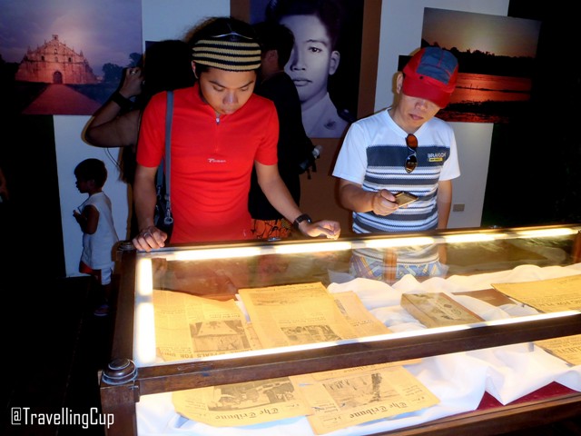
The medals awarded to the late president Marcos were also displayed on the second floor.  There were cut outs from old newspaper  and magazines showing the results of the bar exam in 1939.  There were large paintings, portraits and other memorabilia almost in every panel on the second floor.  The bullets and other ammunition were also displayed in an enclosed glass cabinets.

Adjacent to the mansion is the mausoleum (if you will check on the first photo on the upper left side of this post - that's' the way going to the entrance of the mausoleum.)  This mausoleum is the dwelling place of the remains of the late President Marcos.  Cameras can be brought inside the mausoleum, BUT picture taking is not allowed.  Inside the mausoleum has a pure black walls and ceiling.  The remains of the president is inside the glass casket (I don't know if it's refrigerated or not) and the white flowers were properly arranged in a rectangular position.  I am not so sure about this, but I think the floor is made up of stone-like ceramics forming a mosaic on the ground - this is where the tourists walk.  The mausoleum closes at 4PM.

Saturday, January 5, 2019

Guimaras: Travel Guide

Guimaras tourist spots and attractions
According to survey, the Sweetest Mangoes in the Philippines can be found in Guimaras, an island province in Eastern Visayas region. Guimaras is small, thus, tourists can visit all the tourist spots, attractions, destinations and resorts in the province for five to six hours. Then, taste their local delicacies, with mangoes, at The Pitstop Restaurant.
 

LIST OF TOURIST SPOTS, ATTRACTIONS, DESTINATIONS, CHEAP HOTELS AND RESORTS IN GUIMARAS


HOW TO GET TO GUIMARAS:

Cebu Pacific, Air Asia and Philippine Airlines have their regular trips to Ilo Ilo airport. Then, ride a taxi to Parola Port.

Wednesday, December 27, 2017

Taal Basilica | One of the Largest in Asia

Taal Basilica is one of the Tourist spots in Batangas
Taal Basilica is one of the largest Catholic church in Asia or known as the Minor Basilica of Saint Martin of Tour. This church is one of the must visit tourist spots and attractions in the entire Province of Batangas. This gigantic structure also contains significance in history of the province. Continue Reading >>>

Thursday, October 12, 2017

The Walls of Fort Santiago

Fort Santiago
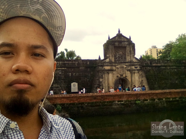
This is part of Celebrating the World Tourism Day 2017 in Intramuros; Fort Santiago was my first destination. Walking beside this gigantic wall is absolutely remarkable as it embarks the significance of the past to current. Just by reading on the writings placed by the management in different corner, you can foresee what have transpired inside this wall centuries ago. Also, we can distinguish who are the prominent people imprisoned and tortured here, like Jose Rizal. Photos below will give you more excitement. Continue Reading >>>

Saturday, January 9, 2016

Mt. Samat | Dambana nang Kagitingan | Bataan

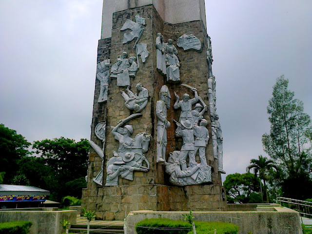
 Dambana ng Kagitingan (Shrine of Valor) is located on the summit of Mt. Samat.  This Historical landmark is a 302-ft Memorial Cross that symbolizes  as a fitting memorial to the heroic struggle and sacrifices of those soldiers who fought and died in that historic bastion of freedom - wikipedia.org.

Honestly, the trip to this historical site wasn't planned properly.  Out plan that time was to have a good time at the beach.  Doing some swimming and island hopping wearing our swim suit.   The weather that day wasn't inviting! I promise.  The sky was dark, raining hard during our travel from Manila, the lighting shines brightly like a sun, the thunder was roaring like a lion in the forest.  And so? we don't care about the weather, we felt more excited for those challenges.

This was my second adventure with some Batang Hamog Mountaineers, and I know from the start that I will enjoy everything despite of the bad weather.  We conquered this site after our Bagac, Bataan Adventure.  The people of Bataan are really great, they let us sleep in their own houses even we don't know them.  So thanks a lot!

Dambana nang Kagitingan
The stairs up to the entrance of the Museum.

Visit Bataan
This is the main entrance going to top of the cross.  No need to worry if you don't want to walk hundred steps, there is elevator that can bring you to the top.

History of Bataan
gorgeous art work!

Freedom Kalayaan
top view of the Museum
Cross in Bataan
the bottom shot of the cross
Death March Bataan
the Entrance
Death March

Shrine of Valor
                                         
Enjoy the video, taken at the Shrine of Valor
Visiting this historical landmark was an amazing experience, with the Batang Hamog Mountaineers.  Although we walked on the 8 kilometer road going to the Shrine of Valor, but then it was a remarkable experience.  We experienced heavy rains and destructive  sun rays.  But in total: that was amazing experience!

Thursday, January 7, 2016

Fort Santiago | Intramuros | Manila

Fort Santiago
Fort Santiago is a fortress which is a part of the structures of Intramuros walls.  This historical structure was first built by Miguel Lopez de Legazpi for the newly founded city of Manila, Philippines. This fort is the most important historical sites in Manila as Dr. Jose Rizal was imprisoned here before he was executed in 1896. 

At the early years, Fort Santiago was a part of the side of a stake wall of Raja Sulaiman, a Muslim chieftain.  It was destroyed by Martin de Goiti (maestre de campo or master of camp) from Cebu on 1570. 

Fort Santiago
Then the Spaniards started building this Fort after the city of Manila was established and made it as the capital of the Philippines under Spanish colonization on June 24, 1571.  

The first fort was a structure of palm logs and earth but it was destroyed during the Chinese invasion led by Limahong.  Then Martin de Goiti was killed during the fight.  The name itself, came from Saint James the Great (or Santiago in Spanish) the patron saint of Spain, where his image can be found in the facade of the main entrance.  Fort Santiago was made from the volcanic stones from Guadalupe, together with the walls of Intramuros in 1590 and was finished in 1593 during Gomez Perez Dasmarinas reign.

Fort Santiago
The gate of Fort Santiago was erected in 1714 with some military bases.  Due to an earthquakes in the year 1880, the city of Manila was destroyed including the structure resulting in changing the character due to damage.

During the American rule in August 13, 1898, their flag was raised in this fort, which means the start of their rule in the Philippines.  It also served as the headquarters of the US Army, who made several changes to the fort.  In World War 2, Fort Santiago was captured by the Japanese Imperial Army and used the prisons, dungeons and cells for the prisoners who were killed near the end of the war.

Execution of Jose Rizal
Final steps of Dr. Jose Rizal before the execution.

Today, at the entrance of Fort Santiago, you can find the bronze foot marks on the ground representing  the final walk of Dr. Jose Rizal from his cell to the location of his actual execution.  This historical structure embraces the heroism of all the Filipino's who fought and gave their lives for the Philippines.  Information taken from wikipedia.org.

Saturday, December 19, 2015

Nagcarlan Underground Cemetery | Laguna

Nagcarlan Underground Cemetery
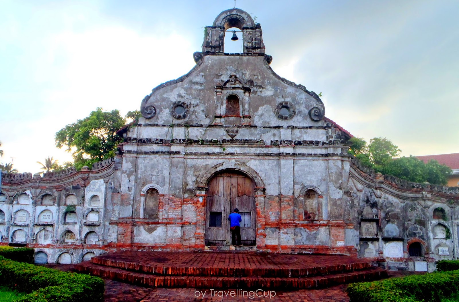
Nagcarlan Underground Cemetery is considered as National Historical Landmark located in Nagcarlan, in the province of Laguna. It is a burial site which is 15 meters below a small chapel; a chapel which was designed for funeral masses in 1845 by Franciscan Priests lead by Fr. Vicente Velloc. If in other parts of the Philippines, their burial sites are hanging (Ifugao), in the cave (Palawan) and concrete crypt (in modern era.) This burial site is unique because of its architectural design and purpose.

Nagcarlan Underground Cemetery
The chapel and the underground graveyard gave a huge impact in history of the province and even the country. It was used as the secret meeting place of the Filipino revolutionary armies, Katipuneros and other members of the KKK. It was also served as the shelter of the Filipino patriots during the Filipino-American War and Filipino guerellas during World War II. 

Outside, the area is surrounded by an artistic fence made of concrete and iron works. Most parts of the fence are covered with bricks which make the structure looks older. In addition to that, crypts can also be seen in almost half of the fence, which got my attention. At the center, is an open area covered with a well-maintained green grass and santan on the side. The concrete pathway made of bricks is the only one that separates the two parts of the ground and connects the main gate to the entrance of the chapel.

Nagcarlan Underground Cemetery
The door of the chapel is tall, wide and thick made up of wood. The chapel doesn’t have anything that we always see in the church. On the right side of the chapel, you can find the stairs going down to the tomb chamber; the oldest tomb was dated 1886. The walls are thick and covered with brown bricks.  According to some details, the people buried to this historical landmark are those came from privileged Catholic families.

Today, the chapel and the graveyard are both no longer operational, but it is still open to the public. No entrance fees to be collected and TAKE NOTE: Please, switch off your camera flash at the graveyard area. Personally, I noticed that the area is well preserved by the locals; but one thing that captured my attention. I think NCCA should do something else to preserve the chapel and the graveyard; particularly the walls, door and floor. At the graveyard, it is really dark; I can suggest, management can place lamps or lights which cannot destroy the historical value of the relics, so that at least the tourists can still see how amazing the graveyard is.  You can also visit: Mt. Mabilog and Bunga Falls

Wednesday, December 16, 2015

Calle Crisologo | Vigan City

Calle Crisologo Vigan
Calle Cristolo or Mena Crisologo  Street is name after Mena Pecson Crisologo who is the most respected sons of Ilocos.  He actually wrote Mining wenno Ayat ti Kararwa which is compared to Jose Rizal's Noli Me Tangere; he is also the author of Don Calixtofaro de la Kota Caballero de la Luna and Codigo Municipal.

What to Visit in Ilocos
Where to stay in Ilocos
Where to Stay in vigan
According to some travellers I spoke to, this street is said to be one of the most beautiful in the Philippines.  This street is close to any type of motor vehicles, but some calesa operates is some parts of the streets.  At first, I smell something I can't recognized in the area, but when I saw the horses, I thought it was the reason of the smell.

The street itself is made up of cobblestone then lined with the heritage houses of the former Filipino-Chinese traders.  Majority of the houses have thick walls made of cement, brown and red bricks; the doors are wide made up of shiny and solid woods; the sliding windows are perfectly made from capiz shells designed with iron grills and wood.  The ceilings are created higher, maybe this is for ventilation purposes.
Where to stay in vigan
where to stay in ilocos
Today, some of the century-old houses were converted into commercial shops, museums, restaurants, cafe and hotels.  Each shops are selling antiques, woven products, bags, basi, chicharon, jewelry, woodcraft and many more.  In night time, the gorgeous light in different colors in each shops added an additional effects that registers in the camera.

Wednesday, December 9, 2015

Cape Bojeador Lighthouse

Cape Bojeador Lighthouse burgos lighthouse

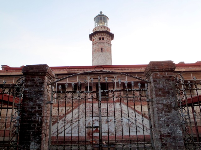
Cape Bojeador Lighthouse (Burgos Lighthouse) is situated in Burgos, Ilocos Norte.  It is a cultural heritage that was erected during the Spanish era in the Philippines.  It's a 66-foot-tall octagonal stone tower on Vigia de Nagpartian Hill with an overlooking scene of Cape Bojeador.

The lighthouse was first designed by Magin Pers and Pers in 1887 and finished by the Lighthouse Service under Guillermo Brockman.  The lighthouse is made up of bricks, the tower is topped with a bronze cupola then the gallery is surrounded by iron grills in different formations.  This site was first lit on March 30, 1892,  but as of right now, it is more than a century years old yet it is still working and still serving as a guide to every ship that enters the Philippines.

If you will check the photos below, the whole structure of this lighthouse is covered with rust-like color that makes the structure old-looking.  The stairs going up to the main entrance of the lighthouse somehow have damages, maybe because of its age.  At the side and rear part of the lighthouse is a cliff with trees that covers the area from strong wind and other possibilities like the thieves.  For more info and photos of each destination, just click the phrases written in yellow.
burgos lighthouse
Cape Bojeador Lighthouse burgos light house
Cape Bojeador Lighthouse
There are two gates entering the structure; one from the entrance and one on the right side.  There is an open space upon entering the main building.  Two stair cases can also be found beside the open space.  That stair case connects the main building to the tower.  The history of this heritage site can be found in the entrance area and engraved on an iron plates.

Monday, December 7, 2015

San Agustin Church | Oldest in the Philippines

San Agustin Church oldest church philippines
San Agustin Church
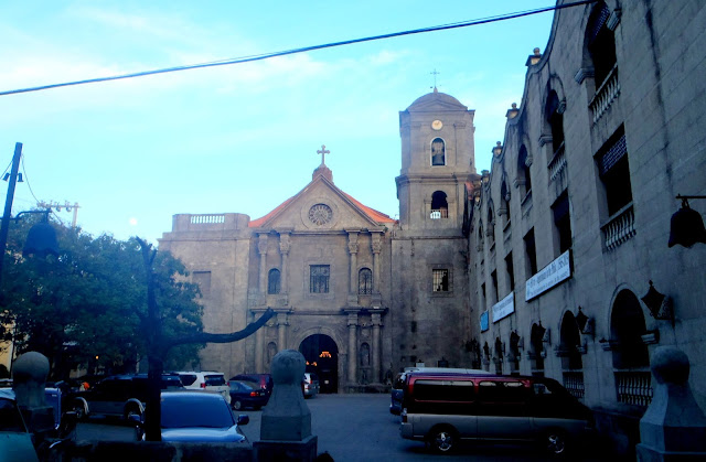
After Manila Cathedral, we walked on the street going to San Agustin Church which is considered as the oldest church in the Philippines. Recognized by the NCCA and UNESCO historical landmark. 

Like the other old churches in the Philippines, this church faced several natural disasters like earthquakes and was burned several times. The very first structure of San Agustin Church was built in 1571 and was made of nipa and bamboo but was destroyed by fire during the invasion of Limahong, a Chinese pirate, in 1574. The same spot, a new structure was built and was made of wood. In 1586, a new structure made of adobe stone was constructed, lead by the Augustinians.

Few years later, strong earthquakes struck Manila resulting for some damaged to the parts of the church. The edifice was renovated several times. San Agustin Church also served as the headquarter and concentration of prisoners during the British war and World War II.

This church is one of the Baroque Churches in the Philippines, like Miag-ao Church in Ilo-Ilo and Paoay Church in Ilocos which are both in UNESCO World Heritage sites. You might wonder why there's only one bell tower, right? Because of the earthquake struck Manila, there were huge cracks on the bell towers. Some were repaired but the left bell tower permanently removed. The facade of this church is really massive and has a great designs. The wooden doors (main entrance and side) are huge and has a great artistic touch.

San Agustin Church

This church houses the tomb of Miguel Lopez de Legazpi and other Spanish conquistadors. While the San Agustin Church Museum contains the collection of Spanish artifacts, paintings and other church ornamental. Inside the church were beautiful chandeliers, paintings and other religious items.

I didn't enter on the church because there was a sermon on going that time and tourists are not allowed to enter, that's the instruction given which was posted at the entrance.  While waiting for Ate Sha, I walked on the street at the left side of San Agustin and I found out that there are old houses in the area which are converted into restos and shops. When we're done with San Agustin, we walked on the street at the right side and proceeded to another side of Intramuros and then Luneta Park.

More photos and information about this travel, click here: 9 Old Churches in Metro Manila

Sunday, December 6, 2015

Lioness Rock Formation

Lioness Rock what to visit in bulacan
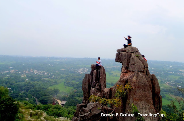
 Lioness Rock Formation is another tourist spot in Bulacan, being known because of great photos uploaded on online blogs. It is where tourists can do a death defying poses and stunts, literally “On the Rock.” This rock formation is named because of its unique rock formation that looks like a “Lioness.” Not only that, in this area we can also find the Monkeys, Rhinos, and Korona rock formations.

Nagsimula ang aming pag-lalakbay sa SM Fairview na kung saan kami sumakay ng jeep patungong Brgy. Bigte, Norzagaray, Bulacan. Dapat wala pang isang oras ang aming naging byahe ngunit sa di inaasahang pagkakataon, naging mabigat ang daloy ng trapiko. Ang pamasahe ay nag-kakahalaga ng 30 pesos.

Bumaba kami sa tinatawag na Rutonda ng Brgy. Bigte, malapit sa palengke. Pag-katapos, sumakay kami ng traysikel patungong Iglesia ni Kristo na malapit sa Paaralang Elementarya ng Bigte, at doon nagsimula ang aming kakaibang karanasan.

lioness rock formation
 Ang daan patungong Lionese Rock Formation ay matatagpuan sa isang pribadong lote na pag-aari ng mga lokal. Ang lahat ng bisita ay inaasahang mag-paalam muna bago mag-simula sa pag-akyat. Ang daan ay maputik at masukal, kaya masusing pag-iingat ang kailangan. May mga kabataang nag-aalok maging guide sa bawat bisita at mas magandang kumuha ng guide dahil delikado ang bawat hakbang.

lioness rock formation
 Ang susunod namang bahagi ay ang simula ng pag-akyat sa mga bato patungong tutok ng Monkeys rock formations. Sabi ng aming dalawang guides, nag-mumukhang isang ungoy daw ang isang bahagi ng batong ito kaya tinawag na monkeys. Medyo mahirap ang parteng ito, dahil masusubukan ang lakas at tatag ng mga braso at binti ng mga umaakyat.  Ngunit ng marating ko ang tutok nito, nakita ko ang gandang itinatago ng Norzagaray, Bulacan.


Darwin Dalisay
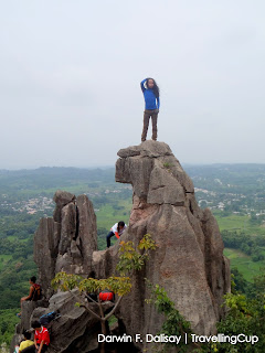
Katabi naman ng monkeys, makikita naman ang kakaibang bato na kahugis ng isang Lion. Nakikita nyo ang mga larawan sa itaas at sa kanan? Para itong ulo ng tinaguriang hari ng kagubatan, diba? Ang nakakatakot lang, base sa aking obserbasyon, ang mga bato ay may malalaking crack na habang tumatagal mas lalong nawawala ang tibay nito, kaya siguraduhing tama ang bawat hakbang. Ang isang maling hakbang ay posibleng maging mitsa ng aksidente. 

Larawan sa Kanan: Ako yan habang ginagawa ang aking “Buwis Buhay Pose.” Sa unang tingin, maski sa ikalawa at ikatlong tingin, hangang may paningin ka, malalaman mo agad na isang imahe ng Lion ang bato, pero dito sa larawang ito, parang akong isang ibong nakatayo sa ulo ng Lion.

BABALA: Sa mga gustong mag-karoon ng mga magagandang larawan, dobleng ingat ang inyong kailangan, kapag malakas ang hangin at hindi kayo komportable, wag nang ituloy!

 Ang susunod na bahagi naman ay ang pag-baba mula sa tutok ng monkeys at Lioness rock formations. Ang parting ito mas mahirap ng kaunti kesa paakyat, marahil mas mahirap makita ang mga aapakang bato. Kaya dito nasukat kung gaanong katatag ang aking mga braso at binti.  Malaking tulong parin ang aking gloves na pang garden at aking sapatos na may makapal na sole. Iwasang mag-dala ng malalaking bag paakyat, katulad ni Te Bing (may pulang bag) na medyo nahirapan, hindi ko alam kung dahil sa bag o dahil maiksi ang mga biyas, kayo na ang mag-husga. Peace Te Bing!

At dahil may dalawang bisita at kanilang guide na nauna sa amin, pinili muna naming kumain ng tanghalian sa isang malinis at patag na lugar, bago umakyat ng Rhinos Rock formation. Wag nyong pahirapan ang inyong mga sarili kung bakit tinawag na Rhinos ang batong ito, mamaya malalaman nyo kung bakit. Sa ngayon, wala munang clue. Ilang minuto din kaming nag-pahinga habang nag-seselfie ang mga nauna sa amin.

 Nung mapansin namin na pababa na ang mga taong nauna, nag-simula narin kaming umakyat sa likod na parte ng Rhinos. Sa parteng ito naman, mas delikado dahil mas matutulis ang mga bato, ngunit mas simpleng ng kaunti, dahil mas maraming kakapitan. Ay may joke pala tungkol sa “kapitan:” may nag-tanong ng: “marami bang kapitan dyan?” Sumagot ang aming guide na si Amboy: “ay hindi po, isa lang po ang kapitan dito!” Sumagot naman ako ng: “Ah, talaga? Eh, Taga saan ba si kapitan?" Hahaha. Sama talaga ng ugali ko no? Binasag ko yung joke nya.

Siguro naman nakikita nyo ang larawan sa itaas, tama? Ito ang paliwanag kung bakit tinawag na Rhinos Rock Formation ang lugar nayan. Base na nakikita nyo, parang isang imahe ng Rhino ang hugis ng batong aking tinutungtungan. Ang butas sa bato ay nag-sisilbing mata ng Rhino, kaya. Ang larawan naman sa kaliwa ay kuha sa itaas na bahagi ng Rhinos, at sa nakikita nyo, matutulis ang mga batong aking kinaroroonan, kaya mas kailangan ang masusing pag-iingat. Pagkatapos ng Rhinos Rock Formations, isinunod naman namin ang Korona Rock Foramation. Ngayon, siguro naman hindi ko na kailangang ipaliwanag kung bakit tinawag itong Korona.

Nag-pahinga kami sa tutok nito ng ilang minuto hanggang sa abutan na kami ng ulan. Ambon lamang ang bumagsak, hindi namin alam na parating na pala si Bagyong Luis. Mas lalong naging delikado ang aming pag-baba dahil mas lalong naging madulas ang mga batong aming tinutung-tungan pababa. Pagkatapos ng mga rock formations, isinunod naman naming ang makasay-sayang kweba ng Norzagaray, click here: Pinagrealan Cave

Need to Consider:
Before reaching the peak of these rock formations, you need to consider different aspects. First will be your health, it is very important, especially if you have the fear of heights, do try it without harness or professionals. You are encouraged to invest for your outfit: rocks are sharp, so your shoes should be dependable and should fit for rock scrambling and climbing. Sole must be thick and can’t be penetrated easily by the sharp rock surfaces. Stretchable shirts and pants are necessary, so you’ll be comfortable in doing the rock scrambling. 

Gloves are needed here because majority of the rock surfaces are sharp, gardening gloves will do. You also need to bring sun block for your skin protection and to avoid skin damage, and insect repellent lotion to protect you from insect bites since the area has shrubs and grasses.  

Sa mga nag-babalak na umakyat sa mga batuhang ito, mas magandang mag-sama kayo ng guide. Sila kasi ang nakakaalam ng mga tamang batong hahawakan at aapakan upang maiwasan kahit papanu ang mga disgrasya. Ibayong pag-iingat ang kailangan!! Bale ang naging budget namin ay nasa 500 pesos lang, bonga diba!